All official European Union website addresses are in the europa.eu domain.
See all EU institutions and bodies
An official website of the European Union | How do you know?
Environmental information systems
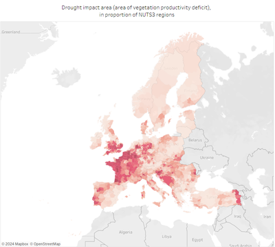
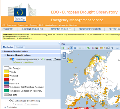
This interactive map shows the land areas currently exposed to drought across the EEA's 38 member and cooperating countries.
To assess the exposure to droughts across Europe, the European Environment Agency uses the EEA Corine Land cover dataset together with the EUNIS habitat classification and the Combined Drought Indicator (CDI) developed by the European Drought Observatory (EDO) of the Copernicus Emergency Management Service, which assesses drought exposure through data on precipitation, soil moisture, and vegetation conditions.
The data are presented in near real-time and updated monthly.
Drought conditions in Europe: 11-20 June 2026
Approximately 22% of the total area of EEA 38 member and cooperating countries experienced drought conditions
37 countries have been affected by drought
Europe faces more intense and prolonged droughts amid climate change
Drought is a natural phenomenon characterized by lower-than-average precipitation over an extended period. Prolonged drought can reduce soil moisture on agricultural land (agricultural drought) and diminish the flow of surface water and recharge of groundwater (hydrological drought). Extended drought conditions, lasting for a season or longer, can place significant stress on our lands, ecosystems and economy.
Climate change projections suggest that the area affected by droughts, along with their frequency, duration, and intensity, is likely to increase across Europe.
As these conditions worsen, managing water resources during extended droughts is quickly emerging as one of Europe’s most pressing challenges.
Read more
Drought may have severe impacts on ecosystems and economy
Measures for reducing the impacts of droughts in Europe
What are the main EU policies addressing droughts and water scarcity?
Related resources
Indicators for monitoring drought occurrences and their impacts in Europe
Reports and assessments on droughts and droughts impacts in Europe
- Water scarcity and droughts page (European Commission)
- ClimateAdapt (European Commission and European Environment Agency)
- Climate change site (European Environment Agency)
- EDO Home - European Drought Observatory (JRC European Commission)