All official European Union website addresses are in the europa.eu domain.
See all EU institutions and bodies
An official website of the European Union | How do you know?
Environmental information systems
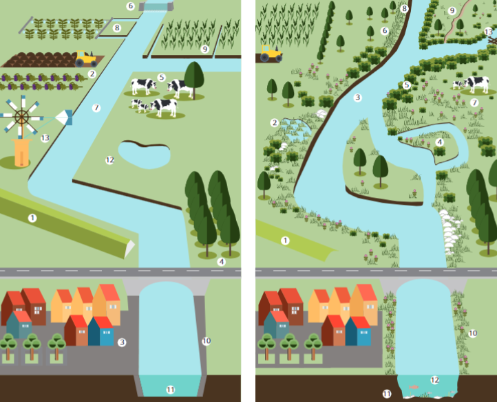
Floodplains are a very important part of the river system because when in their natural state they deliver multiple important ecosystem services and offer protection in a changing climate. Today, they are, however, widely environmentally degraded.
Rivers are much wider than the channels we associate them with. The areas next to rivers, which are covered by water only during floods, are also part of the river system, and these areas act as the interface between the catchment and the river. Known as floodplains, in their natural condition they are an important ecological part of this system: they filter and store water, store CO2, ensure both natural flood protection and the healthy functioning of river ecosystems, and help sustain the high biological diversity present there.
Other freshwater themes pages:
Did you know?
In EEA-39 countries, 7% of the area is located in the potential floodplain and around 12% of the population lives there.
Between 70-90% of floodplains have been environmentally degraded over the centuries
Floodplains can be restored using natural water retention measures that also support delivery of multiple ecosystem services and offer climate protection
In spite of their ecological importance,
floodplains are today widely environmentally degraded
Protection and restoration of floodplains is encouraged by provisions in the Water Framework Directive, the Floods Directive, and the Habitats and Birds Directives. Their restoration is expected to be further enhanced by the Biodiversity 2030 strategy objective to restore 25,000 km of free-flowing rivers.
Discover more about river floodplains
in this storymap
Status
Floodplains have been environmentally degraded as a result of structural flood protection, river straightening, disconnection of floodplain wetlands, agricultural land use and urbanisation over the past two centuries. A preliminary assessment of floodplain condition based on two indicators of lateral connectivity suggest that a large share of floodplains is substantially to severely degraded (FIGURE 1 and FIGURE 2).
Figure 1
Habitat area loss indicator
This indicator shows deviations from natural vegetation patterns.

Figure 2
Land use pressure indicator
This indicator shows catchments where urbanization and agriculture are predominant activities.

Source: Preliminary assessment of river floodplain condition in Europe. ETC/ICM Report 5/2020
The large pressures on the floodplains are also reflected in the conservation status assessment performed under article 17 of the Habitats Directive. Selecting those listed habitats that are found in floodplains, only 17% are found in favourable conservation status, and for some large biogeographic regions none are in favourable conservation status (Figure 3).
Figure 3
Conservation status of European floodplains across biogeographical regions.
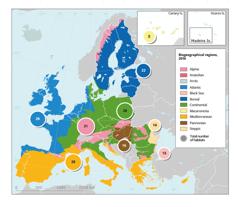
Source: Floodplains: a natural system to preserve and restore. EEA Report No 24/2019
Note
Each dot represents an assessment outcome on the biogeographical scale. The analysis encompasses nine floodplain forest habitats, nine floodplain grassland habitats and 19 aquatic floodplain habitats.
More about this topic
Floodplain restoration
Related Resources
Data and maps
Dashboards
Publications
References
The main references used in this page are:
- A preliminary assessment of river floodplain condition. ETC/ICM Report 5/2020
- Floodplains: a natural system to preserve and restore. EEA Report No 24/2019
- Why should we care about floodplains? EEA Briefing 2018
- Tracking barriers and their impacts on European river ecosystems. EEA Briefing 2021